
🤗 Model | 📄 Technical Report | 📊 Data | 💻 Code | 🌎 Embeddings Explorer | 🗺️ Interactive Narrative
Today, we are officially releasing OlmoEarth v1.3, a state-of-the-art (SOTA) satellite imagery embedding model. Alongside the release of OlmoEarth v1.3, we are sharing globally precomputed annual embeddings (at 10-meter resolution in both 64- and 128-dimensional formats), as well as a brand-new browser-based tool—the OlmoEarth Embeddings Explorer—for exploring and customizing maps built on these embeddings. This means anyone can immediately start using OlmoEarth v1.3, whether for tracking land surface changes over time or discovering similar landscapes—no login or deep technical expertise required.
Previously, the primary way to use OlmoEarth was through fine-tuning in OlmoEarth Studio: training models for specific tasks and running them over satellite imagery to generate maps. This approach required access to GPU compute, as well as the capacity to download and store satellite imagery. In contrast, embedding models compress satellite data into ready-to-use features, allowing them to be reused across diverse tasks at a fraction of the cost.
With OlmoEarth v1.3, we are thrilled to give users more ways to explore and work with planetary-scale data artifacts, enabling everyone to work in the way that best fits their needs.
Compute Once, Reuse Everywhere
Embedding vectors represent the knowledge and representations learned by the model from millions of images. OlmoEarth v1.3 ingests a full year of time-series satellite data from radar (Sentinel-1) and multispectral sensors (Sentinel-2 and Landsat) to produce a 128-dimensional vector for every 10-meter resolution pixel on Earth. The first 64 dimensions can also be extracted independently for use as a smaller, lightweight embedding.
Foundation models and global-scale embedding data are exceptionally expensive to produce. To democratize access to these advancements, we precomputed these embeddings globally and made them fully open to the community on Source Cooperative. With these embeddings, crop mapping, land cover classification, and surface change analysis become lightweight modeling tasks: training a small classifier directly on top of the embedding features is all it takes to run locally.
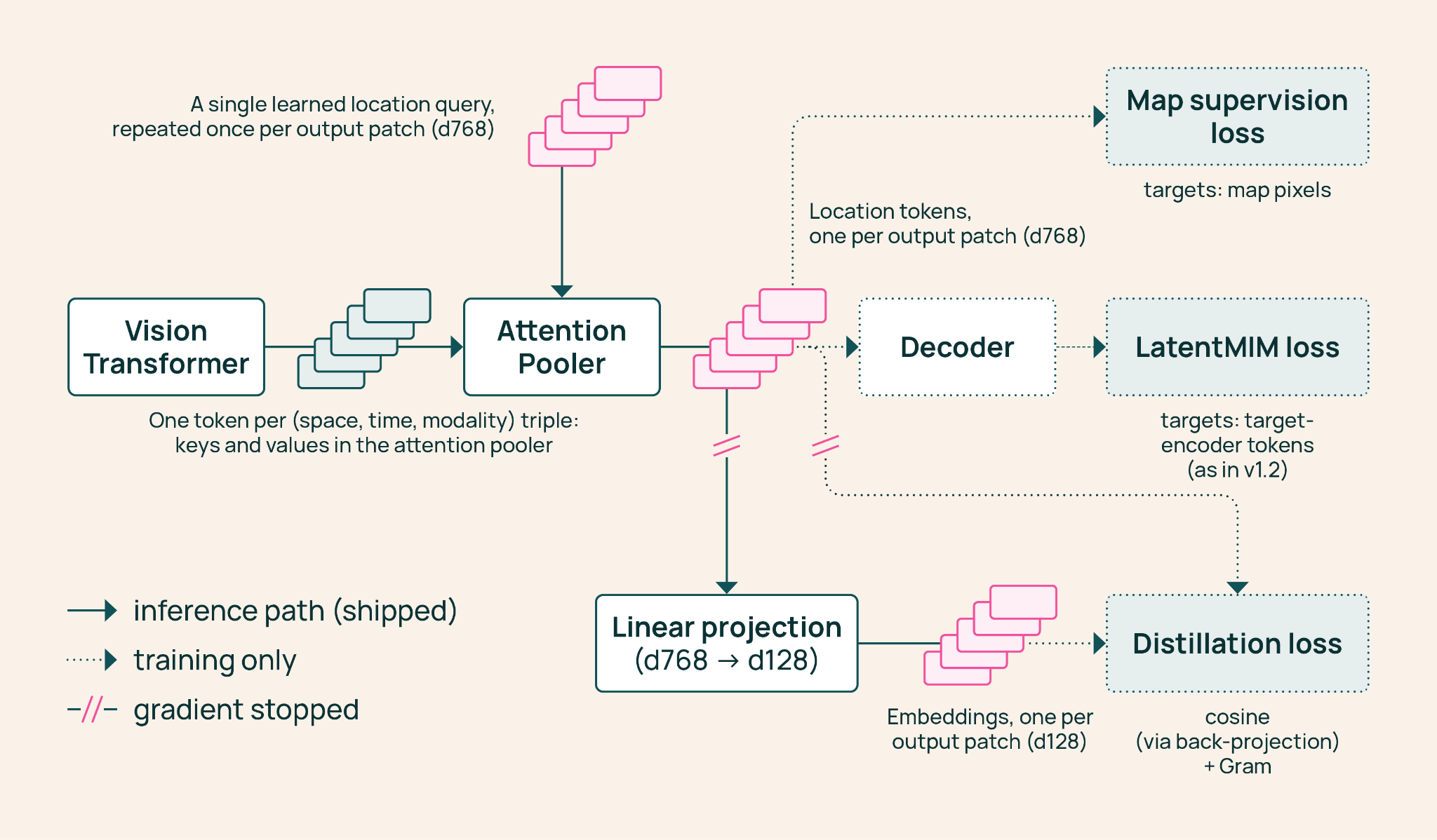
How OlmoEarth v1.3 produces embeddings: A Vision Transformer reads satellite data, an Attention Pooler aggregates it into a single vector per land patch, and a linear layer projects it down to 128 values.
State-of-the-Art Embeddings
We evaluated OlmoEarth v1.3’s embedding performance against AlphaEarth Foundations (AEF) and Tessera v2 across 27 benchmarks spanning six continents and a variety of distinct tasks. OlmoEarth’s 128-dimensional embeddings achieved the top score in 20 out of 27 benchmarks, ranking first overall. The half-size 64-dimensional version still led on 18 of the 27 benchmarks. As part of this evaluation, we introduced PLANTEUR: A new crop type benchmark for tropical agriculture, demonstrating that these embeddings exhibit remarkable generalization to regions never seen by the classifier (see the PLANTEUR technical report here). Every component behind this work is fully open source: including model weights, pretraining data, and pretraining code.
In practice, this means training a small classifier on top of OlmoEarth embeddings is sufficient to accurately map ground conditions: from classifying crops of Kenyan smallholders and detecting brick kilns west of Dhaka, to assessing fire burn severity in Indonesia and tracking illegal gold mining in the Peruvian Amazon.
Compared to previous generations of OlmoEarth models, OlmoEarth v1.3 is also the most cost-effective to train. Its compute time is just 53% of the previous version (v1.2) and 18% of the first generation (v1), with carbon emissions representing only 50% and 22% of those models, respectively. At the same time, it remains a robust base model for fine-tuning, delivering performance on par with v1.2 across various research and partner-labeled datasets. Our latest model builds upon the underlying architecture of earlier OlmoEarth releases, with targeted optimizations to ensure embeddings remain lightweight without sacrificing downstream task accuracy—an efficiency gain that will carry forward into future releases.
Full results and